National Calibration Center home page

NOAA-20/J1 Visible Infrared Imaging Radiometer Suite (VIIRS)

JPSS-1, now known as NOAA-20, is the second spacecraft within NOAA's next generation of polar-orbiting satellites which was
launched in November 18, 2017. Capitalizing on the success of Suomi NPP, the JPSS-1 spacecraft boasts five similar instruments:
(1) VIIRS, (2) CrIS, (3) ATMS, (4) OMPS-N, and (5) CERES-FM6. Instruments can also be called sensors or payloads. JPSS-1 will take advantage of the successful technologies developed through the Suomi NPP satellite. JPSS-1's design life is seven years. The Visible Infrared Imaging Radiometer Suite (VIIRS) is one of the key instruments onboard the NOAA-20 spacecraft. It collects visible and infrared imagery and global observations of land, atmosphere, cryosphere and oceans.
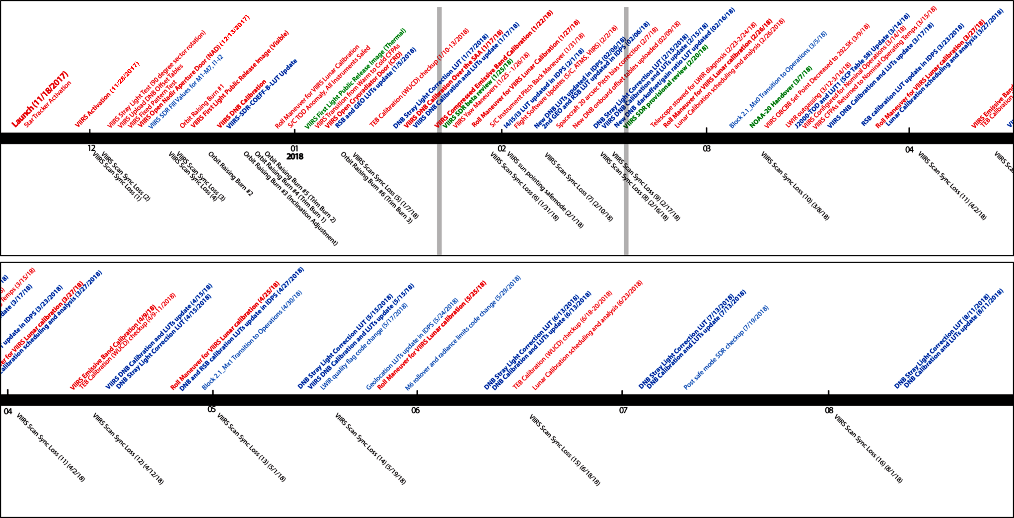
News and Documents VIIRS Performance and Monitoring Data and Software
VIIRS special issue
in Remote Sensing
- NOAA-20/SNPP Equator Crossing (plot)
- NOAA-20/SNPP Equator Crossing (data)
NOAA Open Data Dissemination (NODD)
VIIRS SDR/L1B download (NRT/Reprocessed)
VIIRS FAQ Daily Orbit Predictions VIIRS data on NOAA CLASS Archive
VIIRS Users Guide Validation Site Time Series VIIRS Near Real Time Globle Map
(JSTAR Mapper)
VIIRS Calibration ATBD Radiometric Intercomparison with MODIS VIIRS Near Real Time
Full Resolution Regional Validation Sites
VIIRS data for beginners VIIRS Calibration Events log Global 20+ Site Validation System (G20)
VIIRS Applications VIIRS Geolocation Validation VIIRS Image Gallery
VIIRS SDR Data Format VIIRS Instrument Performance Monitoring (ICVS) VIIRS Software Tools

VIIRS On-orbit Performance Table Planck Calculator for Infrared/Passive
Microwave Remote Sensing
About VIIRS Standardized Calibration Parameters
VIIRS Publications NOAA-20 VIIRS Spectral Response Functions

Lunar Calendar for DNB
NOAA-20 VIIRS as GSICS
on-orbit reference
Moon in Space View Events


NOAA-20 events

image: Image acquired by VIIRS

Mission Notice :

11/29/2017: After JPSS-1 launched into Earth orbit, the satellite, now known as NOAA-20, has sent back its first Advanced Technology Microwave Sounder (ATMS) science data.

11/18/2017: The Joint Polar Satellite System-1, the first in a new series of four highly advanced NOAA polar-orbiting satellites,
lifted off from Vandenberg Air Force Base, California, at 1:47 a.m.

VIIRS paper:

Cao, C., F. DeLuccia, X. Xiong, R. Wolfe, F. Weng, Early On-orbit Performance of the Visible Infrared Imaging Radiometer Suite (VIIRS) onboard the Suomi National Polar-orbiting Partnership (S-NPP) Satellite, IEEE Trans. on Geosci. and Remote Sens.,
Volume: 52 , Issue: 2, Digital Object Identifier: 10.1109/TGRS.2013.2247768, Publication Year: 2014 , Page(s): 1142 - 1156.
(click here)

Cao, C., X. Shao, X. Xiong, S. Blonski, Q. Liu, S. Uprety, X. Shao, Y. Bai, F. Weng, Suomi NPP VIIRS sensor data record verification, validation, and long-term performance monitoring, Journal of Geophysical Research: Atmospheres, DOI: 10.1002/2013JD020418, 2013. (click here)

Uprety, S., C. Cao, X. Xiong, S. Blonski, A. Wu, and X. Shao, 2013, Radiometric Inter-comparison between Suomi NPP VIIRS and Aqua MODIS Reflective Solar Bands using Simultaneous Nadir Overpass in the Low Latitudes, JTech, doi: http://dx.doi.org/10.1175/JTECH-D-13-00071.1.


For questions and comments, please contact yan.bai@noaa.gov.